We study the emergence, effects, and costs of land-use-based climate mitigation and adaptation actions. Drawing on geography, economics, and data science, our projects use large-scale Earth observations, social spatial data, and novel inferential methods to answer questions in three knowledge domains:
- Effectiveness of conservation interventions
- Cost estimation for conservation planning
- Valuing environmental amenities and climate risks
Current research projects are funded by the National Science Foundation (NSF, 2 grants) and the National Aeronautics and Space Administration (NASA, 1 grants).
Effectiveness of conservation interventions

Governments, individuals, and local communities dedicate substantial funding to land protection for the benefit of public environmental goods, such as carbon stocks, biodiversity, and recreational values. These efforts come in many shapes: parks, regulations, sustainable use areas, recognition of indigenous land rights, land acquisitions, conservation easements, carbon credits, etc. What difference do they make? How can we choose between them?
Earth observations and counterfactual impact estimation methods give us rapidly advancing tools to observe outcomes and estimate causal effects, allowing us to ask questions such as: How much forest loss did a type of conservation policy avoid? How do its effects depend on characteristics of the intervention, involved actors, and lands? Can we predict which intervention types will achieve goals most cost-effectively?
Findings
- Buy or rent forests? In Colombia, local governments can choose. We find that BANCO2 – a program that offers temporary payments to farmers – expanded quickly and covered larger, more threatened forest areas than public land acquisitions. However, we estimate that BancO2’s causal (“additional”) effects on forests were smaller than those of acquisitions. As a result, temporary payments might not be more cost-effective in maintaining or increasing forest cover than purchasing the land (Reboredo Segovia et al., 2026, review & resubmit, Proceedings of the National Academy of Sciences, NASA webinar).
- Colombia has the largest public land acquisition program for conservation in the tropics. We find that, since 1993, local governments purchased thousands of properties within the range of hundreds of species. Most acquired land was observed in wealthier municipalities with cheaper land – not in the municipalities with the most threatened ecosystems (Reboredo Segovia et al. 2022 Conservation Letters).
- In Massachusetts, voluntary long-term land conservation (land acquisitions and conservation easements) reduced forest loss and development without displacing it to neighboring lands (Nolte et al. 2019 Conservation Letters).
- Argentina’s federal forest law reduced deforestation in the endangered Chaco ecosystem – in spite of strong incentives to let zoning “follow the market” (Nolte et al. 2017 Ecological Economics, response, rejoinder).
- In the Brazilian Amazon, indigenous lands were more successful at resisting high deforestation pressures than strictly protected areas and sustainable use areas, irrespective of the intensity of federal enforcement (Nolte et al. 2013 Proceedings of the National Academy of Sciences).
- More publications
Past projects
- Comparing the effectiveness of conservation instruments in the Colombian Andes biodiversity hotspot
NASA Land Cover / Land Use Change, 2020-2025

Past projects have been supported by the National Science Foundation, the Gordon and Betty Moore Foundation, the Rights and Resources Initiative, The Nature Conservancy, National Geographic, Boston University’s College of Arts and Sciences and the Hariri Institute for Computing and Computational Science and Engineering.
Cost estimation for conservation planning

How can ambitious conservation goals – such as conserving 30% of the planet by 2030 – be achieved with limited budgets? Spatial planning algorithms can identify cost-effective locations to achieve diverse conservation goals, e.g., to restore forest carbon, to protect species habitat, or to enhance access to recreation. However, cost estimates are rarely available at the scale where conservation decisions ultimately occur: the individual property. We develop novel, large-scale, parcel-level datasets (n>150M) and scalable statistical methods to predict observed spatial variation in the cost of long-term conservation actions (e.g., acquisitions, easements) across large landscapes. We revisit work that proposes cost-effective spatial priorities for species conservation and show that they are affected by the quality of cost estimates.
Findings
- In the Colombian Andes, we derived new high-resolution conservation cost estimates from data on 2,094 acquisitions from 106 local governments. This allowed us to identify new cost-effective protected area networks for 143 threatened bird species. Cost proxies used in global conservation analyses (agricultural rent, land use intensity) miss important patterns but can be improved through international collaboration on cost datasets (Nolte et al, 2024, Frontiers in Ecology and the Environment).
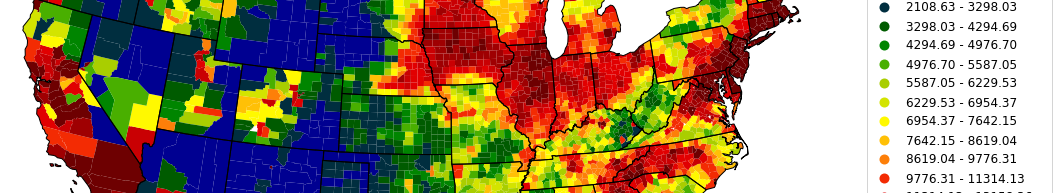
- Our high-resolution estimate of land value from data on 6 million sales in the United States is, to our knowledge, the most accurate published predictor of the actual cost of public land acquisitions (n=4119). If true, more funding will be needed to achieve conservation goals under climate change than earlier studies assume, e.g. in floodplain protection and habitat protection (Nolte 2020 Proceedings of the National Academy of Sciences).
- More publications
Current project
- High-resolution prediction and uncertainty estimation of land value and conservation costs in the contiguous United States
NSF Human-Environment and Geographic Sciences, 2022-2027
Past research has been supported by the National Institute for Mathematical-Biological Synthesis (NSF), The Nature Conservancy, as well as the College for Arts and Sciences and the Hariri Institute for Computing and Computational Science and Engineering at Boston University.
Valuing environmental amenities and climate risks

Property sales data are frequently used to estimate how much residents value environmental amenities and risks associated with the location of their property. However, publication bias and “researcher degrees of freedom” can lead to exaggerated effect sizes, contributing to a potential credibility crisis in empirical economics. Access to large-scale property data permits replication and testing of findings, but poses new challenges for data quality, computation, and inference. We led efforts to increase the precision, transparency, and replicability of large-scale valuation studies and related property analyses, developed software and protocols to synthesize analysis-ready datasets on computing clusters, and organized web workshops (2020-22) with >400 participants from >150 U.S. institutions.
Findings
- We documented five under-reported challenges in synthesizing large-scale property sales data (e.g. arms-length filters, geolocation, temporal linkages). We show they can affect results as much as choices on model specification and variable selection, but are rarely reported in the peer-reviewed literature. We call for better documentation to reduce “researcher degrees of freedom” and enhance credibility of value estimates (Nolte et al. 2024 Land Economics).
- Christoph Nolte joined senior editors Daniel Phaneuf, Jeffrey Zabel, and Kevin Boyle to put together “Property value analysis using ZTRAX: Applications under the Approaching Sunset“, a Joint Special Issue in Land Economics and the Journal of Housing Economics (a first!) featuring large-scale property value analyses in the U.S.
- We showed that individual buildings, not aggregate units (ZIP code areas, census tracts) are the appropriate spatial unit of analysis in large-scale flood risk estimation: risk estimates from aggregate input data are biased if flood hazard and building value are correlated (as they are in Massachusetts) (Pollack et al. 2023 Journal of Flood Risk Management).
- More publications
Current projects
- LakeSense: A portal for nationwide remotely sensed lake water quality indicators to inform benefit-cost analyses for federal and state-level rulemaking
NASA Water Resources Applications, 2023-2027
- Large-scale CoPe: Coastal Hazards, Economic prosperity, and Resilience
NSF Coastlines & People, 2022-2027
Past research has been supported by the College for Arts and Sciences and the Hariri Institute for Computing and Computational Science and Engineering at Boston University.